Entertainment Xander Ford New Look: Clinics, Cosmetic Surgeons and Telephone Numbers By admin October 2, 2017
Entertainment WATCH: Marlou Arizala aka Xander Ford New Look ‘The Big Reveal’ on Rated K By admin October 1, 2017
Entertainment Kisses Delavin, Liza Soberano, Julia Barretto, Kathryn Bernardo Winners at Star Magic Ball 2017 By admin October 1, 2017
Entertainment WATCH: Star Magic Ball 2017 Red Carpet Live, Photos and Videos By admin September 30, 2017
Entertainment WATCH: Pinoy Singer Lance Busa is First-Ever Grand Winner of Michael Bolton’s Talent Show ‘Bolt of Talent’ By admin September 29, 2017
Entertainment WATCH: Morissette Amon Wows With Mariah Carey’s ‘Emotions’ on Asia Song Festival 2017 in Korea By admin September 28, 2017
Entertainment WATCH: Pinay Singer Crowned Winner at ASEAN Singing Contest in Vietnam By admin September 9, 2017
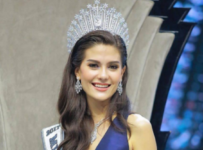
Entertainment WATCH: Laura Lehmann Crowned Winner of Miss World Philippines 2017 By admin September 3, 2017
Entertainment WATCH: Maymay Entrata and Edward Barber Movie “Loving in Tandem” Trailer Released By admin August 31, 2017
Entertainment Mother of Charice Claims Jake Zyrus Life Story on ‘MMK’ is Full of Lies By admin August 27, 2017
Celebrity Gossip WATCH: Former PBB Housemate Wil Dasovich Diagnosed With Cancer By admin August 24, 2017
Entertainment WATCH: Kid Singer Celine Tam Sings “When You Believe” on America’s Got Talent 2017 Live Shows By admin August 23, 2017
Entertainment WATCH: Miss World Philippines 2017 Sports Challenge Finalists Named By admin August 18, 2017
Entertainment Chris Pratt and Anna Faris Are Separating After 8 Years of Marriage By admin August 7, 2017
Entertainment WATCH: Miss Earth USA 2017 Finals Full Video, Andreia Gibau of Massachusetts Wins Crown By admin August 6, 2017
Entertainment WATCH: Mutya Ng Pilipinas 2017 Grand Coronation, Live Results and Winner By admin August 4, 2017
Entertainment WATCH: Miss Universe Thailand 2017 Full Show, Maria Poonlertlarp Ehren Wins Title By admin July 30, 2017
Entertainment LOOK: Ahron Villena Posted Photo Showing His Private Part on Instagram By admin July 28, 2017
Entertainment US President Donald Trump Blocks John Legend’s Wife Chrissy Teigen on Twitter By admin July 26, 2017
Entertainment Xian Gaza Invites Daniel Matsunaga For Tea After Erich Gonzales Rejects His Offer By admin July 18, 2017
Entertainment Tawag Ng Tanghalan Champ Noven Belleza Arrested For Alleged Rape By admin July 17, 2017
Entertainment WATCH: Karen Ibasco From Manila Wins Miss Philippines Earth 2017 By admin July 15, 2017